Today for work, I sat home in my pajamas most of the day learning about the people, plants and places of southern Louisiana. I have made a small career out of being familiar with New Jersey (to the point which that I got a famous author/internet personality to publicly and personally apologize to me for dissing the great Garden State). I don't have that same knowledge base here, but I'm working on building some foundation for understanding the local context.
Things I knew about Louisiana before coming here:
- The capital is Baton Rouge.
- I learned in Geography of Eastern North America in college that there's some sort of "cancer alley" from all of the chemical production going on.
- However, being from New Jersey, I will not base my entire opinion of LA on one minor pollutiony detail.
- The Mississippi River dumps into the Gulf of Mexico here, and there's all sorts of wetlands, and they might be shrinking or there might be changes in hydrology and sedimentation patterns because of development stuff I think?
- Probably some other stuff.
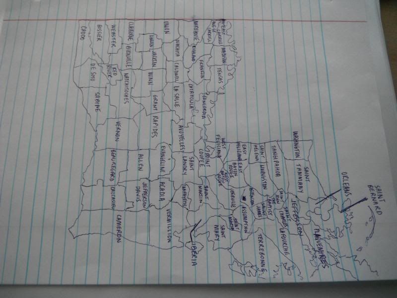
- Louisiana has 64 parishes, government areas based on historical Catholic church area divisions.
- New Orleans is in Orleans Parish.
- Bayou Blue and the wetlands area I toured on Sunday are in Terrebonne Parish.
- Number of parishes I'm sure I'm pronouncing incorrectly: at least seven
- Number of parishes I'm probably pronouncing incorrectly: almost all of them that aren't distinctly English or include "Saint" in the name, which is a lot.
- There are 9 parishes named Saint ______.
- Favorite parish name: Natchitoches, probably because I'm not saying it correctly
- Least favorite parish name: Saint Martin, because there appears to be two of them?!
- Just kidding, upon further investigation, it appears that it's just discontinuous. Still confusing.
- State tree: Bald Cypress (I can live with that, though I'm kind of surprised it's not the live oak.)
- State bird: brown pelican
- State flower: magnolia (also a viable candidate for state tree, as far as I'm concerned)
- They have an absurd number of state symbols, including the state crustacean, state meat pie, state jellies (there are two) and state vegetable AND vegetable plant (two different things).
- There are 4 tribes involved with First Peoples' Conservation Council (FPCC). None are federally recognized.
- There are 10 state recognized tribes, including the Isle de Jean Charles (whose kind and hilarious chief I met last Friday, who is actively involved with the FPCC) and Point-au-Chien (the wonderful people we hung out with on Sunday).
- In the past 80 or so years, Louisiana has lost an area of wetlands totaling approximately the size of the entire state of Delaware. An area the size of Manhattan disappears about annually.
I welcome any and all fun facts and solid resources for this stuff. Bring it.

Of COURSE there's a state crustacean. And meat pie. And...jelly?
ReplyDelete